CONTOUR MAP
Objective:
- Draw a geological cross-section along XY.
- Construct a 185m borehole at a location of (650,380)
Pre-requisites:
Topographic map
Description Contour lines: are curved, straight or a mixture of both lines on a map describing the intersection of a real or hypothetical surface with one or more horizontal planes.
Identify the borehole location and line about which the profiles are to be drawn.
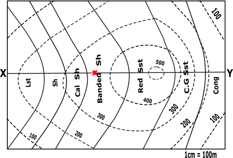
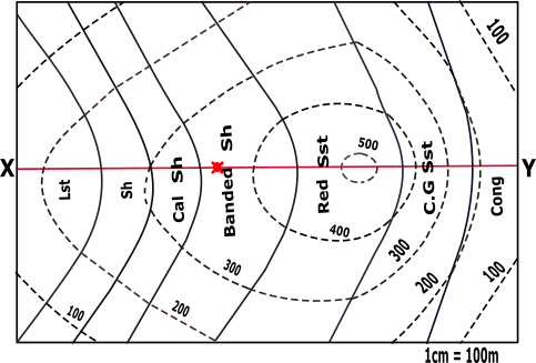

Line to be considered for profiles to be drawn:
Borehole Location
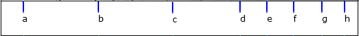
Mark all the points of XY line that is obtained by the intersection of the dotted line with this XY of the contour map.

| Points | X-Co | Y-Co |
|---|---|---|
| a | x1 | 200 |
| b | x2 | 300 |
| c | x3 | 400 |
| d | x4 | 500 |
| e | x5 | 500 |
| f | x6 | 400 |
| g | x7 | 300 |
| h | x8 | 200 |
Identify X-axis and Y-axis taking X as origin and define scale.
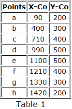
Plot the points taking its distance from X as x coordinate and the index values of the corresponding line as y coordinate along with the points Y’ (1535,0) on the graph.
| Points | X-Co | Y-Co |
|---|---|---|
| a | 90 | 200 |
| b | 400 | 300 |
| c | 710 | 400 |
| d | 990 | 500 |
| e | 1100 | 500 |
| f | 1210 | 400 |
| g | 1330 | 300 |
| h | 1420 | 200 |
Mark all the points of XY line that is obtained by the intersection of the solid line with this XY of the contour map.

| Points | X-Co | Y-Co |
|---|---|---|
| p | x1 | y1 |
| q | x2 | y2 |
| r | x3 | y3 |
| s | x4 | y4 |
| t | x5 | y5 |
| u | x6 | y6 |
Name the points as p,q,r … respectively taking its distance from X as x-coordinate.
| Points | X-Co | Y-Co |
|---|---|---|
| p | x1 | y1 |
| q | x2 | y2 |
| r | x3 | y3 |
| s | x4 | y4 |
| t | x5 | y5 |
| u | x6 | y6 |
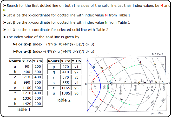
To Calculate the index value of the solid line.
➤Search for the first dotted line on both the sides of the solid line.Let their index values be M and N.
➤Let α be the x-coordinate for dotted line with index value M from Table 1
➤Let β be the x-coordinate for dotted line with index value N from Table 1
➤Let ¥ be the x-coordinate for selected solid line from Table 2.
➤The index value of the solid line is given by
➤For α>β:Index= (N*(α- ¥)+M*(¥- β))/( α- β)
➤For α<β:Index=(N*(¥- α )+M*( β-¥))/( β- α)
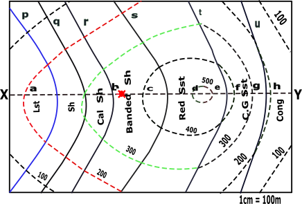
Calculate the index value of all solid lines.
Hint
| Points | X-Co | Y-Co |
|---|---|---|
| a | 90 | 200 |
| b | 400 | 300 |
| c | 710 | 400 |
| d | 990 | 500 |
| e | 1100 | 500 |
| f | 1210 | 400 |
| g | 1330 | 300 |
| h | 1420 | 200 |
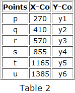
| Table 2 | ||
|---|---|---|
| Points | X-Co | Y-Co |
| p | 270 | y1 |
| q | 410 | y2 |
| r | 570 | y3 |
| s | 855 | y4 |
| t | 1165 | y5 |
| u | 1385 | y6 |

➤For the solid line p:
Plot the above points (p to u) with the plotted points (a to h) along with the points Y’ (1535,0) on the graph.
| Points | X-Co | Y-Co |
|---|---|---|
| p | 270 | 258 |
| q | 410 | 303 |
| r | 570 | 355 |
| s | 855 | 452 |
| t | 1165 | 441 |
| u | 1385 | 239 |
Join all the plotted points on the graph. And extrapolate it between the bounds.
Mark borehole point at a location of (650,380).
Calculation for Angle of dip.
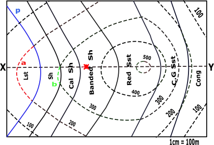
➤Search for the points of intersection between the solid line and the dotted line on the contour map.
T1=100 T2=200
T2>T1

θ=45º
From the points (p,q,r,s,t,u) draw a line at an angle θ with horizontal in anticlockwise direction and its point of intersection on x-axis be (p’,q’,r’,s’,t’,u’) respectively.
➤p-p’☚
➤q-q’☚
➤r-r’☚
➤s-s’☚
➤t-t’☚
➤u-u’☚
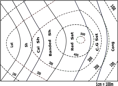
Location of types of stones on the contour.
➤Lst☚
➤Sh☚
➤CalSh☚
➤BandSh☚
➤RedSst☚
➤CGSst☚
➤Cong☚
Construct a 185m borehole at a location of (650,380).
Profile View Graph


Both ends of the pipe must be trimmed to ensure parallel faces.